
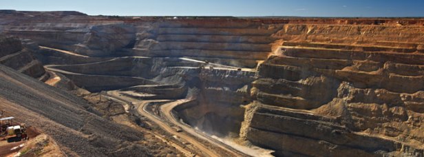
As autonomous mining is now taking off in a big way, the need for 100% coverage for the haul trucks and other equipment in the pit is mission critical. Regardless of the communication technology used today – Wi-Fi, LTE, etc. – there must be a level of high confidence in the radio coverage plan to ensure the continuous operate of the autonomous mining equipment. If there are gaps in the coverage, then the equipment stops working. In fact, all of the equipment ceases to function if even one haul truck loses its connection. When a haul truck load of ore might be valued at $100,000.00, and you have 20, 30, 40, 50, or 60 haul truck rolling in the pit, then any work stoppage can be astronomically expensive. As well, the entire end-to-end workflow can be disrupted, so it is not just the haul trucks that get impacted by poor radio coverage. To describe the radio coverage as vital is somewhat of an understatement.

So, what is the best way to approach radio frequency (RF) coverage in a large scale open pit mine? The first thing to consider is that a mine is like a giant ameba, in so much as it is ever-changing. One day a road is there, and the next day it is not. Mines are very dynamic and operating autonomous haul trucks on roads demands a precise level of awareness for the mines, the benches, the roads, the dump sites, and more. It is a full time job to map the current mine model into the autonomous truck over-watch systems. This mapping is akin to writing video games, there are challenges to overcome, hurtles to climb, obstacles to circumvent, and grades to climb and descend – all safely for workers and equipment. Yes, workers will still exist in an autonomous mine for maintenance, updates, adjustments, inspections, and services.
So, providing 100% coverage can be challenging. You may start out very well covered, but if you do not adapt to the dynamic changes to the mine topology, then coverage will slowly degrade until it is lost. Mines are three-dimensional too, with some pits nearing 1,000 feet deep. So, flat earth coverage will not work. You need precision 3D modelling.
In order to model a mine correctly, you require several elements to function in perfect harmony. These elements include:
- RF Propagation Modelling Software
- GIS Mapping Software
- Digital Terrain Elevation Data
- Resource Data
- Suitable Algorithms for the bands and the environment
- A Qualified Operator to run these systems
- A Feedback Loop to validate the models, so they can be optimized

RF Propagation Modelling Software
There are several good RF propagation modelling software packages available off the shelf from credible vendors. Examples include: TAP from Softwright, Radio Mobile, SPLAT!, EDX Wireless, Siradel, CelPlan, PathLoss, Mentum Planet, and many more. Some tools are offered as online web services and most are loaded into a higher powered computer for local operation. All of these modelling tools were originally designed for specific purposes and bands. For example, Radio Mobile was designed for Amateur Radio enthusiasts. TAP and EDX have strong legacy backgrounds in broadband uses like broadcasting. And Siradel and CelPlan have normally been offered as a service.

GIS Mapping Software
RF modelling in a computer is powerful, but we still need to make it meaningful to the users, so some high grade mapping tools are necessary to overlay to the terrain data and make sense of the facilities. ESRI is the most common and powerful tool. A fast following, second contender geographic information systems (GIS) is Google Maps Pro. But, using the online maps can limit the quality of the maps, so most serious users leverage the capabilities of ESRI or equal, and if quality map data is not readily available then they create maps from high resolution aerial images taken of the mine site. Like the DTED discussed below, these maps need to be updated, typically annually or every six months, so it can be expensive to secure good quality maps for remote parts of the world, thus Google Maps Pro can be used if there is no better available alternatives.

Digital Terrain Elevation Data
Getting good terrain data is critical to modelling success. Luckily, this sort of data is often readily available in the mining industry. There are many sources for data such as the SRTM data that is freely available from JPL (Jet Propulsion Laboratory) online. While the resolution of the SRTM is not ideal, sometimes it is the best or only DTED available for remote mine locations. It is often suitable for ‘indicative’ modelling, rather than for final engineered uses. Data from LiDAR equipped drones, aircraft (fixed or rotary wing), or satellite are all available for a cost. Actual survey data is still used in some cases too.

The Shuttle Radar Topography Mission (SRTM) is an international research effort that obtained digital elevation models on a near-global scale from 56°S to 60°N, to generate the most complete high-resolution digital topographic database of Earth prior to the release of the ASTER GDEM in 2009. SRTM consisted of a specially modified radar system that flew on board the Space Shuttle Endeavour during the 11-day STS-99 mission in February 2000,
The Advanced Spaceborne Thermal Emission and Reflection Radiometer (ASTER) Global Digital Elevation Model (GDEM) was developed jointly by the Ministry of Economy, Trade, and Industry (METI) of Japan and the United States National Aeronautics and Space Administration (NASA).

The ASTER GDEM covers land surfaces between 83′ N and 83′ S and is comprised of 22,600 1′-by-1′ tiles. Tiles that contain at least 0.01% land area are included. The ASTER GDEM is in GeoTIFF format with geographic lat/long coordinates and a 1 arcsecond (approximately 30m) grid. It is referenced to the WGS84/EGM96 geoid. Pre-production estimated (but not guaranteed) accuracy for this global product were 20m at 95% confidence for vertical data and 30m at 95% confidence for horizontal data.
Resource Data
Resource Data is technical information from the mine based infrastructure that is used to communicate to the mining equipment, such as haul trucks. You need a myriad of precise data to map the mine communications systems into the modelling tool. You need latitude / longitude of all radios, heights above ground level (AGL), transmit power, received thresholds, antenna gains, Smith Charts for the antenna patterns, MIMO, power control, and beam-forming data, and a lot more in order to accurately model how this infrastructure will send and receive the wireless signals.

Algorithms
There are many recognized propagation models to use, some are specific to certain frequencies and applications, so selecting the right algorithm is critical to success. They are not all the same and the results can vary dramatically. Here are a few popular algorithms to consider:
The Longley-Rice (aka Irregular Terrain Model) Propagation module is the most flexible and popular propagation module. It is valid for a wide frequency range from approximately 30 MHz to 30 GHz. The Longley-Rice model is an implementation of many of the equations presented in the NTIA Tech Note 101. In addition to expected parameters such as frequency, effective radiated power (ERP), antenna pattern and antenna heights a number of other parameters unique to Longley-Rice are employed. These include such things as climate and soil conditions, ground conductivity and dielectric constant.

The Bullington model, computed free space field strength is adjusted for obstruction attenuation for knife-edge diffraction based on the method described in “Radio Propagation for Vehicular Communications” by Kenneth Bullington (IEEE Transactions on Vehicular Technology, November 1977). Facility and path parameters (transmitter power, directional antenna, beam tilt, earth curvature correction, antenna heights, etc.) are all user-specified to provide maximum flexibility in system design. Bullington is widely used for link and land mobile coverage and is the best model for air to ground prediction and also in rugged terrain. It computes field intensity values at specified radial, tile or individual locations, based on terrain data for a site and path, transmitter power, directional antenna, etc., using free space field and the Bullington obstruction loss method.

The Okumura model computes basic median field strength and then adjusts for factors such as terrain, type of area (urban, suburban, open, etc.), terrain slope, etc. from the families of curves, as described in “Field Strength and its Variability in VHF and UHF Land-Mobile Radio Service”, Review of the Electrical Communications Laboratory, Vol. 16, Numbers 9-10, Sep.-Oct, 1968, by Yoshihisa Okumura, et. al. The Okumura adjustments for area type, terrain slope, street orientation, etc., can be included or excluded individually from calculations. Facility and path parameters (transmitter power, directional antenna, beam tilt, earth curvature correction, antenna heights, etc.) are all user-specified to provide maximum flexibility in system design. Field intensity values are calculated at specified radial, tile or individual locations, based on terrain data for the site and path, transmitter power, directional antenna, etc., using basic median field and adjustments based on the Okumura method.
Okumura is most prominently used for predicting field strength in urban areas since the underlying measurements were taken in Tokyo, Japan. However, corrections for Suburban and Open terrain are included, if needed. The explicit frequency range is 150 MHz to 1920 MHz although extrapolations up to a few GHz are not uncommon. The Okumura curves directly apply to propagation distances of 1 km – 100 km although, again, the curves can be extrapolated for longer ranges.

The Carey module uses topographic elevation information to compute height above average terrain (HAATs) from a specified site. This information is used to compute an area contour from the f(50,50) and f(50,10) Carey curves from Part 22 of the FCC Rules. Distance to service contours for Cellular Geographic Service Area (CGSA) are also calculated, as well as the calculations described in FCC Report and Order 94-201. The Carey Module also allows calculation of the f(50,90) values based on f(50,50) adjusted according to Figure 5 from R-6406.
The Broadcast (Part 73) and Carey (Part 22) propagation models are based on the pertinent sections of the U.S. FCC Rules and Regulations. Both of these methods are essentially simplified statistical methods of estimating area coverage based only on a station’s effective radiated power (ERP) and height above average terrain (HAAT). Since the terrain information is averaged, neither model takes into account specific individual localized obstructions or shadowing. Also, since the average used for these models only includes the terrain between three (3) and sixteen (16) kilometers from the transmitter site, terrain obstructions outside of this range are ignored. This means that identical results will be calculated whether or not a transmitting antenna has clear line of sight or complete blockage by an obstruction in the first 3 kilometer portion of a path. Likewise, any terrain obstructions beyond 16 kilometers that block the line of sight to a more distant receiving antenna are ignored. The main use for either of these models is for license applications or other submissions to the FCC which specifically require the use of the methods described in Part 73 or Part 22 of the FCC Rules, or other administrative requirements, such as certain frequency coordination procedures.
On the other hand, Bullington, Okumura, and Longley-Rice are more analytical models that consider a number of other factors, such as individual obstructions (either terrain or manmade), terrain roughness, etc. Okumura is often used in urban environments and includes correction factors for various area types, such as urban, suburban, etc. Bullington considers individual obstructions and computes losses, for example, for terrain obstructions, ridges, etc. Longley-Rice is a general model that considers radio horizons and various environmental conditions.
The Hata/Davidson model uses developed empirical formulas derived from the many Okumura families of curves. The calculations depend upon which type of environment is present in the coverage area – urban, large city, small/medium size city, suburban or open area. Although Hata’s model requires the inclusion of transmitting and receiving antenna heights it does not contain any of the path-specific corrections included in the more detailed Okumura Propagation model.
There are many more models and many that are variations of these core themes to add new capabilities or for use in different environments.

Qualified Operator
Likely the most important element is the person operating the systems to perform the modelling for you. It is not enough to spend the money and buy the tools. This is half science and half art. So, securing the services of the right operator is essential to your success. All too often, I have seen companies buy tools and then rarely use them. When they do use them, the people become the weakest element in the equation. So, unless you can make use of this sort of professional every day, it may be smarter to use a services bureau to perform the work for you and with your input. Again, the level of collaboration and interaction with the operator is normally deep and takes time. Most of the time, we seek help from an outside company and I enjoy a positive and successful relationship with CelPlan. They have provided me with experts of the highest caliber who I trust and respect. Typically, these operators have a masters or PhD in mathematics or geography.

Feedback Loop
No amount of modelling or money spent will make for perfect coverage modellings. It is an iterative process and not a one-time event. Drive testing at regular intervals of the mine, often weekly is required. The data from these drive tests in compared to the predictive model and then the predictive model is tweaked to optimize it. In my experience, a first pass predictive model can be 50% to 75% correct. It will never be perfect. But, to increase the accuracy of the model and your trust in it, a feedback loop can bring it to 95% or 98% accuracy. Drive testing can reveal holes or gaps in your coverage plan and then trailer based back fill antennas can close these gaps.
I envision some new tools that provide constant 24 hour a day feedback. These systems can be added to the haul trucks and provide continuous correction to the design tools based upon the actual signals that the haul truck receives.

Conclusions
So, if autonomous mining is a part of your next project, then be sure to give some serious thought to the way that you model your RF coverage plans. You can waste a lot of money with poor modelling. It is essential to make use of the right tools for the job. Some, like Radio Mobile are useful for indicative modelling, but for production modelling you must get into the big, expensive tools that run $50,000.00 to $100,000.00 per seat. But, it is the person who sits in that seat that makes it perform, so never skip on the human element. The tools are useless in the hands of a poor performing person and they can make magic happen in the hands of the right person.
References
Softwright. (2019). Detailed TAP Module Descriptions. Softwright, LLC. Retrieved on April 22, 2019 from, https://www.softwright.com/knowledgebase/detailed-tap-module-descriptions/
About the Author:
Michael Martin has more than 35 years of experience in systems design for broadband networks, optical fibre, wireless and digital communications technologies.
He is a Senior Executive with IBM Canada’s Office of the CTO, Global Services. Over the past 14 years with IBM, he has worked in the GBS Global Center of Competency for Energy and Utilities and the GTS Global Center of Excellence for Energy and Utilities. He was previously a founding partner and President of MICAN Communications and before that was President of Comlink Systems Limited and Ensat Broadcast Services, Inc., both divisions of Cygnal Technologies Corporation (CYN: TSX).
Martin currently serves on the Board of Directors for TeraGo Inc (TGO: TSX) and previously served on the Board of Directors for Avante Logixx Inc. (XX: TSX.V).
He serves as a Member, SCC ISO-IEC JTC 1/SC-41 – Internet of Things and related technologies, ISO – International Organization for Standardization, and as a member of the NIST SP 500-325 Fog Computing Conceptual Model, National Institute of Standards and Technology.
He served on the Board of Governors of the University of Ontario Institute of Technology (UOIT) and on the Board of Advisers of five different Colleges in Ontario. For 16 years he served on the Board of the Society of Motion Picture and Television Engineers (SMPTE), Toronto Section.
He holds three master’s degrees, in business (MBA), communication (MA), and education (MEd). As well, he has diplomas and certifications in business, computer programming, internetworking, project management, media, photography, and communication technology.
Very interesting article.
L Lee Parsons
MGP CITY PLAN LTD
LParsons@MGPCity.com
Mobile +1 416 618 7473