
The use of commercial drones in business is now becoming mainstream and offer many industries cost effective and high value solutions. In the telecommunications industry, drones are ideal for performing tasks that were previously expensive to deliver and had inherent risks.
Tower Inspections
Tower inspections is one area where drones excel and they deliver high performance inspections, with high resolution images and video. When combined with artificial intelligence platforms to analyze the still images and video, advanced analysis can be completed without having engineers to physically climb towers. The risks and the liabilities are greatly reduced since the recorded images captured in the field result in new opportunities for sharing and post-processing to further enhance the drone value proposition

Photographs and Video

At MICAN Communications, we offer tower inspection services in Canada. We use advanced drones to record razor sharp photos of your tower structures. With an industry leading 1″ CMOS sensor that is capable of capturing a 20 million pixel still image, the 5472×3648 image quality is unparalleled with 10 bit colour depth. With a crisp wide angle lens offering a 28 mm (35mm equivalent) image with a field of view of 77°, this technology will focus as close as 1 metre to record the tiniest details necessary for an in-depth inspection. Images are available in JPEG or RAW file formats.
Video footage is available in high definition, shot at 1920×1080 pixels in the Progressive format. As well, super high definition is available at a stunning 4k resolution for 3840×2160 with a frame rate of 24/25/30, all in Progressive scan.

With these super high resolutions, no detail is missed. It can be fed into an artificial intelligence (AI) platform for efficient analysis and reporting. Human inspection can follow where the AI directs, and uncovers concerns or issues.
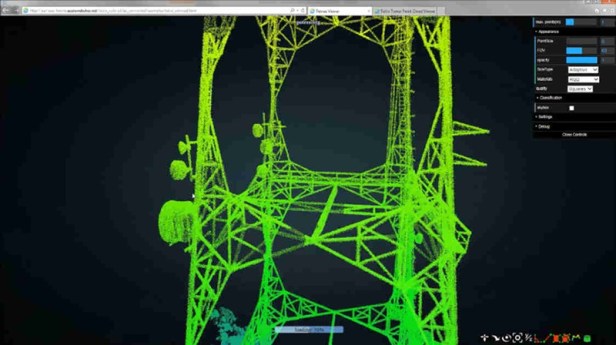
Digital Twins
A Digital Twin model in 3D can result to represent your field assets and allow for “what if?” scenarios and asset management recording. Annual updates can be automated with data fed into your asset management platform.

Digital Twins could also be used for the effective management of mobile cell towers, particularly those in remote locations which can be difficult to maintain. Comprising several pieces of equipment, including antennae, power generators, and surveillance cameras, these towers require continuous monitoring. To enable this, remote sensors can collect a range of data, on aspects such as proximity, temperature, motion and position, which can then be analyzed using AI/ML algorithms before being fed into a digital twin of the tower itself. By viewing the digital twin as a replica of the tower, operations and field service management teams would then be able to address any issues that arise. What is more, as tower site technology tends to be multi-vendor, the insights provided by the digital twin could be shared as a service to the various equipment providers, thereby monetizing the data.
Infrared Thermal Sensors
With infrared cameras attached instead of the video / still camera, thermal imaging of your tower is available to identify hot spots and reveal leaks in power lines.If you do not catch distribution power-line problems early, you may end up dealing with a costly outage that disrupts power to thousands of customers. That is why regular inspections are necessary. But there is a lot the naked eye can miss, especially when you cannot get close enough to what you need to inspect. Equipment gets hot before it fails – regular thermal imaging surveys on distribution power-lines can give you a full picture of potential problems. Since the components you need to inspect are small and likely located out of reach, a high-resolution thermal imager or drone with a combination of infrared and visual payloads can help you detect potential problems quickly and accurately from a distance. Identify hot spots early so you can prevent failures before they occur, reducing the cost of maintenance and repairs.
Electromagnetic Sensing
An induction coil can also be added to the drone to log radiation leaks and electromagnetic field emissions. In the Utility industry, this sensor can detect your infrastructure before it fails thereby eliminating or limiting costly downtime. Placing a magnetometer on unmanned aerial vehicle (UAV) seems to be an easy task as the sensor is rather lightweight in comparison with other geophysical sensors. For the quality of magnetic survey, the most important is the issue of a platform’s (UAV) magnetic noise and its influence on a magnetic sensor. MICAN drones are measured and removed from the analysis recordings.
LiDAR

When the payload is switched to the LiDAR sensor, the earth can be mapped to sub one metre resolution, effectively to a few centimetres for precision accuracy. Trees and foliage can be captured and measured too. This allows the vegetation canopy to be properly managed and helps record a safe environment for reference and site grooming. Remote sensing means that we are not actually physically measuring things with our hands. We are using sensors which capture information about a landscape and record things that we can use to estimate conditions and characteristics. To measure vegetation or other data across large areas, we need remote sensing methods that can take many measurements quickly, using automated sensors. LiDAR, or light detection ranging (sometimes also referred to as active laser scanning) is one remote sensing method that can be used to map structure including vegetation height, density and other characteristics across a region. LiDAR directly measures the height and density of vegetation on the ground making it an ideal tool for scientists studying vegetation over large areas. LiDAR is an active remote sensing system. An active system means that the system itself generates energy – in this case, light – to measure things on the ground. In a LiDAR system, light is emitted from a rapidly firing laser. You can imagine light quickly strobing from a laser light source. This light travels to the ground and reflects off of things like buildings and tree branches. The reflected light energy then returns to the LiDAR sensor where it is recorded.A LiDAR system measures the time it takes for emitted light to travel to the ground and back. That time is used to calculate distance traveled. Distance traveled is then converted to elevation. These measurements are made using the key components of a LiDAR system including a GPS that identifies the X,Y,Z location of the light energy and an Internal Measurement Unit (IMU) that provides the orientation of the plane in the sky.
Differential GPS
When differential GPS is used, centimetre resolution of the local terrain can be mapped and used for design and analysis work. Differential correction techniques are used to enhance the quality of location data gathered using global positioning system (GPS) receivers. Differential correction can be applied in real-time directly in the field or when post-processing data in the office. Although both methods are based on the same underlying principles, each accesses different data sources and achieves different levels of accuracy. Combining both methods provides flexibility during data collection and improves data integrity.

The underlying premise of differential GPS (DGPS) is that any two receivers that are relatively close together will experience similar atmospheric errors. DGPS requires that a GPS receiver be set up on a precisely known location. This GPS receiver is the base or reference station. The base station receiver calculates its position based on satellite signals and compares this location to the known location. The difference is applied to the GPS data recorded by the second GPS receiver, which is known as the roving receiver. The corrected information can be applied to data from the roving receiver in real time in the field using radio signals or through post-processing after data capture using special processing software. Real-time DGPS occurs when the base station calculates and broadcasts corrections for each satellite as it receives the data. The correction is received by the roving receiver via a radio signal if the source is land based or via a satellite signal if it is satellite based and applied to the position it is calculating. As a result, the position displayed and logged to the data file of the roving GPS receiver is a differentially corrected position.

The Advent of 5G Cellular
With the advent of 5G now upon us, using drones for selecting prospective sites and securing critical site look angles and signal coverage perspectives is vital. With so many sites to be constructed in the next few years. drones site surveys will be mission critical for cost savings and fast, efficient performance analysis.

Operator Licencing
In Canada, all drone operators must be duly licenced and maintain their piloting education to satisfy the rigorous Transport Canada criteria. The MICAN operators hold these Advanced certificates issued by the federal government so they can request permission to fly drones in special circumstances and locations, often in densely populated settings where others cannot fly.

If you own or operate towers for telecommunications, let MICAN help you capture critical information in a cost effective manner. We can share this information via a web portal so the data is readily available from any location behind secure log-ins with Two-Factor Authentication to protect your confidential information.
You can learn more about MICAN Communications at the company web site. The address is: https://micancommunications.com/ or just press this link to be expressed to the site.
MICAN
Contact Michael Martin at 416-729-9991 or call the office at 416-287-3400. Email Michael at michael.martin@micancommunications.com
————————–MJM ————————–
References:
Cherkasov, S. & Kapshtan, D. (2017). Unmanned Aerial Systems for Magnetic Survey. Dimensions. Retrieved on July 3, 2020 from, https://badge.dimensions.ai/details/id/pub.1105235699
Chivers, M. (2020). Differential GPS Explained. ESRI. Retrieved on July 3, 2020 from, https://www.esri.com/news/arcuser/0103/differential1of2.html
FLIR. (2019). Application Spotlight: Distribution Powerline Inspections. FLIR Systems Inc. Retrieved on July 3, 2020 from, https://www.flir.ca/instruments/utilities/application-s/
Pal, S. (2018). Managing Future Telecom Networks with a Digital Twin. 5G Technology World. Retrieved on July 3, 2020 from, https://www.5gtechnologyworld.com/managing-future-telecom-networks-with-a-digital-twin/
Wasser, L. (2020). The Basics of LiDAR – Light Detection and Ranging – Remote Sensing. NEON – National Science Foundation. Retrieved on July 3, 2020 from, https://www.neonscience.org/lidar-basics
————————–MJM ————————–
About the Author:
Michael Martin has more than 35 years of experience in systems design for applications that use broadband networks, optical fibre, wireless, and digital communications technologies.He is a business and technology consultant. He offers his services on a contracting basis. Over the past 15 years with IBM, he has worked in the GBS Global Center of Competency for Energy and Utilities and the GTS Global Center of Excellence for Energy and Utilities. He is a founding partner and President of MICAN Communications and before that was President of Comlink Systems Limited and Ensat Broadcast Services, Inc., both divisions of Cygnal Technologies Corporation (CYN: TSX).Martin currently serves on the Board of Directors for TeraGo Inc (TGO: TSX) and previously served on the Board of Directors for Avante Logixx Inc. (XX: TSX.V). He has served as a Member, SCC ISO-IEC JTC 1/SC-41 – Internet of Things and related technologies, ISO – International Organization for Standardization, and as a member of the NIST SP 500-325 Fog Computing Conceptual Model, National Institute of Standards and Technology.He served on the Board of Governors of the University of Ontario Institute of Technology (UOIT) [now OntarioTech University] and on the Board of Advisers of five different Colleges in Ontario. For 16 years he served on the Board of the Society of Motion Picture and Television Engineers (SMPTE), Toronto Section. He holds three master’s degrees, in business (MBA), communication (MA), and education (MEd). As well, he has three undergraduate diplomas and five certifications in business, computer programming, internetworking, project management, media, photography, and communication technology. He has earned 15 badges in next generation MOOC continuous education in IoT, Cloud, AI and Cognitive systems, Blockchain, Agile, Big Data, Design Thinking, Security, and more.